

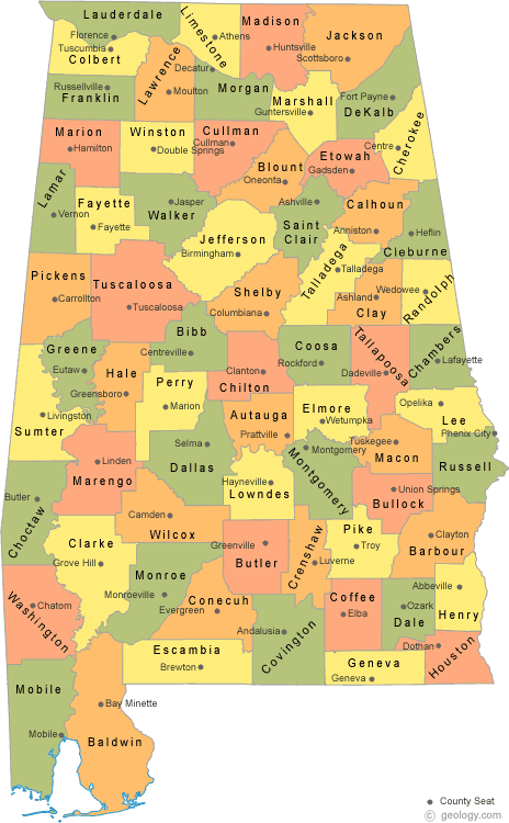
 The
U.S. state of Alabama has 67 counties. Each county serves as the local
level of government within its borders. The land enclosed by the
present state borders was joined to the United States of America
gradually. Following the American Revolutionary War, West Florida was
ceded to Spain by treaty while the remainder was organized primarily
as the Mississippi Territory, and later the Alabama Territory. The
territorial assembly established some of the earliest county divisions
that have survived to the present, including the earliest county
formation, that of Washington County, created on June 4, 1800. In
1814, the Treaty of Fort Jackson opened the territory to American
settlers, which in turn led to a more rapid rate of county creation.
Alabama was admitted to the Union as the 22nd state in 1819. The
Alabama state legislature formed additional counties from former
native lands as the Indian Removal Act took effect and settlers
populated different areas of Alabama. In 1820, Alabama had 29
counties. By 1830 there were 36 and Native Americans still occupied
large areas of land in northeast and far western Alabama. By 1840, 49
counties had been created; 52 by 1850; 65 by 1870; and the present 67
counties by 1903. Houston County was the last county created in the
state, on February 9, 1903.
The
U.S. state of Alabama has 67 counties. Each county serves as the local
level of government within its borders. The land enclosed by the
present state borders was joined to the United States of America
gradually. Following the American Revolutionary War, West Florida was
ceded to Spain by treaty while the remainder was organized primarily
as the Mississippi Territory, and later the Alabama Territory. The
territorial assembly established some of the earliest county divisions
that have survived to the present, including the earliest county
formation, that of Washington County, created on June 4, 1800. In
1814, the Treaty of Fort Jackson opened the territory to American
settlers, which in turn led to a more rapid rate of county creation.
Alabama was admitted to the Union as the 22nd state in 1819. The
Alabama state legislature formed additional counties from former
native lands as the Indian Removal Act took effect and settlers
populated different areas of Alabama. In 1820, Alabama had 29
counties. By 1830 there were 36 and Native Americans still occupied
large areas of land in northeast and far western Alabama. By 1840, 49
counties had been created; 52 by 1850; 65 by 1870; and the present 67
counties by 1903. Houston County was the last county created in the
state, on February 9, 1903.
.....Read more from Wikipedia.....
Alphabetical List of Alabama Counties
Year Formed List of Alabama Counties
Map of Alabama Counties